
Caltrans QuickMap Frequently Asked Questions
- Where can I find a description of Caltrans QuickMap?
- Can you tell me more about the traffic information displayed on Caltrans QuickMap?
- Where does the information on the map come from?
- How often is the information on the map refreshed?
- Why did the open info window pop-up disappear?
- How can I report an issue or ask a question?
- Can I embed QuickMap in my web page?
- Can I display QuickMap on my media broadcast?
- How do I use the Commercial Vehicles layer tools in the QuickMap app?
Q: Where can I find a description of Caltrans QuickMap?
A: Right here:
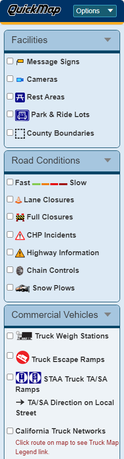
The Caltrans QuickMap web page presents several types of real-time traffic information layered on a Google Map. The information includes traffic speed, lane and road closures due to construction and maintenance activities, incident reports, Changeable Message Sign (CMS) content, camera snapshots, and active chain control requirements. Traffic speed is indicated by color-coded lines overlaying the roadway. The location of information content for the remaining layers is identified by markers (icon images) on the map. Clicking on a marker displays the information details in an info window pop-up.
The presentation of these different categories of information can be controlled with check boxes in the Caltrans QuickMap drop down menu labeled Options which enables the layers to be turned on or off. This also serves as a key to the marker images used for each type of information.
Also see: Can you tell me more about the traffic information displayed on Caltrans QuickMap?
Navigation
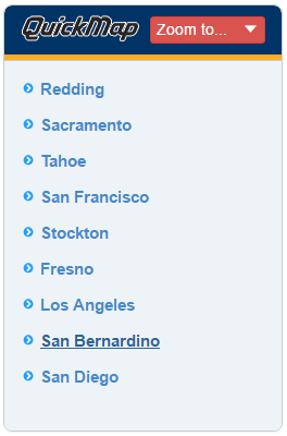
Left-click one of the Zoom to ... links in the page's drop-down menu to reach a pre-defined location and zoom level.
You can also navigate (pan and zoom) around the map using the standard methods of Google Maps:
- Point at the map, left-click, and hold to drag the map to view adjacent sections.
- Pan left, right, up and down with the arrow keys.
- Pan wider with the Page Up, Page Down, Home and End keys.
- Zoom in and out with the plus (+) and minus (-) keys.
- Point at the map and double left-click to zoom in and center on the location pointed to.
- Double right-click to zoom out (Ctrl+ double-click for Mac users).
- Use the scroll wheel on your mouse to zoom in and out.
- Use the Google Navigation Controls (on the right side of the map) by:
- Clicking the appropriate arrow buttons to move the view north, south, east or west.
- Click + to zoom in on the center of the map.
- Click - to zoom out.
- Drag the zoom slider up or down to zoom in or out incrementally.
Caltrans QuickMap will save your location and zoom level between sessions. So the next time you visit the page from the same system you will be viewing the same location on the map.
If your browser is capable of location aware browsing, and configured to share your location, you can click the "Locate" button (upper left side of the map) to pan to your current location with a zoom level of 12.
Sharing a View
You can save the current location and zoom level by clicking on the "Share" button (upper left side of the map) and copying the displayed URL. The URL contains arguments for the location and zoom level, and can be pasted into a browser's address bar.
Road Map, Terrain, or Satellite
By default, the traffic layers are displayed on the standard Google road map. Clicking the "Satellite" button (upper left side of the map) replaces the road map with Google Earth satellite images. Clicking the "Map" button resets the display of the road map. Clicking the "Terrain" check box (made visible by pointing at the "Map" button while the road map is displayed) adds a physical map overlay based on terrain information. Clicking the "Labels" check box (made visible by pointing at the "Satellite" button while the road map is displayed) adds location labels to the map.
Text Information
Much of the information presented by Caltrans QuickMap is also available from a text-based Highway Conditions web page accessible in the Caltrans QuickMap drop down menu labeled Links. To view this information, enter the highway number in the input field and click on the nearby "check" button. Or, for a spoken version call: 1-800.427.7623. This information does not include the California Highway Patrol (CHP) incidents, but does include the lane closures, Caltrans Highway Information Network (CHIN) messages, and chain controls.
Regional 511 Links
In addition to the information presented by Caltrans QuickMap, there are links to regional 511 sites accessible in the Caltrans QuickMap drop down menu labeled Regional Sites. These sites are provided by other organizations, in partnership with Caltrans, to supply comprehensive, commuter and multi-modal, traveler information within their regions.
Links to travel information in our neighboring states (Arizona, Nevada, and Oregon) can be found by clicking the "Other States" button and selecting the appropriate state link.
Q: Can you tell me more about the traffic information displayed on Caltrans QuickMap?
A: Yes.
Traffic Speed 
The traffic speed data information is provided by using the Google Maps Traffic Layer. This enables Caltrans QuickMap to provide speed data beyond what is available using just Caltrans data. Google uses Caltrans data as well as other sources of data, like Automated Vehicle Location (AVL) from private companies, as well as cellular phone data. The colors represent speeds. Green means there is a normal speed of traffic. The more red the roads become, the slower the speed of traffic.
For more information on the Google Traffic Layer see the following links:
- http://support.google.com/gmm/bin/answer.py?hl=en&answer=45854
- http://googleblog.blogspot.com/2009/08/bright-side-of-sitting-in-traffic.html
- http://google-latlong.blogspot.com/2009/08/arterial-traffic-available-on-google.html
Lane Closures 
The lane closures layer presents construction and maintenance activities by Caltrans .
Although the data files on the public servers include all active and planned lane closures, Caltrans QuickMap only shows the active lane closures. Planned Lane closures can be found using the Planned Lane Closures link accessible in the Caltrans QuickMap drop down menu labeled links or by visiting the main Caltrans web page: Caltrans.
The Lane Closure data files are updated every 5 minutes.
The Caltrans QuickMap drop down menu labeled Options enables the layer to be turned on or off.
Lane Type Descriptions
The following are descriptions of common lane types used in managed lane facilities:
- HOV lanes: These are lanes open only to vehicles with a minimum number of occupants and other vehicles expressly authorized by state and federal law, such as motorcycles.
- High Occupancy/Toll (HOT) lanes: These are HOV lanes that can also be accessed by tolled vehicles that do not meet the occupancy requirements.
- Express Toll Lanes: All vehicles pay a toll to access these lanes; discounts may be offered for certain classes of vehicles, such as HOVs.
- Bus lanes: These lanes can be used exclusively by transit buses and other common carriers.
- Truck-only lanes: These lanes can be used exclusively by commercial vehicles to separate them from general purpose traffic. They may be tolled.
- Part-time lanes: These are lanes where a portion of the roadway is open for travel only at certain times of the day.
California Highway Patrol (CHP) Incidents 
Roadway incidents are presented using the publicly available CHP incident feed. CHP incidents are indicated by red triangular markers.
The CHP incident layer is updated every 1 minute.
The Caltrans QuickMap drop down menu labeled Options enables the layer to be turned on or off.
Caltrans Highway Information Network (CHIN) Incidents 
CHIN incidents that involve closed lanes are indicated by orange triangular markers.
The CHIN incident layer is updated every 1 minute.
The Caltrans QuickMap drop down menu labeled Options enables the layer to be turned on or off.
Message Signs 
The Message Signs layer presents CMS markers only for signs with active messages. Caltrans QuickMap does not show markers for signs that are not currently displaying messages. The info window pop-up displays the message as it is shown on the CMS.
The Message Signs layer is updated every 1 minute.
The Caltrans QuickMap drop down menu labeled Options enables the layer to be turned on or off.
Cameras 
The Cameras layer presents selected still images from cameras throughout the State. Still images were selected instead of providing full motion imagery to insure that the web page would be able to provide traveler information even during high demand periods. Since the camera images were never intended for use by the public when originally installed, Caltrans is currently working to upgrade and standardize the image quality and information provided. The period between image updates varies by location, depending on the communication technology currently used. The goal is to provide image updates every 20 minutes or less.
The Caltrans QuickMap drop down menu labeled Options enables the layer to be turned on or off.
Chain Controls 
The Chain Controls layer presents the active chain control requirements throughout the State. A tire with chains is used for all restrictions. Restrictions are outlined in the info window pop-up. The chain control levels used in California are shown in the table below.
| Level | Description listed in dialog box |
| ESC | The CHP is escorting all traffic due to weather conditions. |
| HT | All traffic is being held at the chain control check point due to incidents or weather related conditions. |
| MAX | Truck chain requirements are maximum for all trucks. |
| MIN | Truck chain requirements are minimum for all trucks. |
| R-0 | There are no chain restrictions at this time. |
| R-1 | Chains are required on all vehicles except passenger vehicles and light-duty trucks under 6,000 pounds gross weight and equipped with snow tires on at least two drive wheels. Chains must be carried by vehicles using snow tires. All vehicles towing trailers must have chains on one drive axle. Trailers with brakes must have chains on at least one axle. |
| R-1M | Trucks & vehicles pulling trailers use R-1 restrictions. |
| R-2 | Chains or traction devices are required on all vehicles except four wheel/ all wheel drive vehicles with snow-tread tires on all four wheels. (Four wheel/all wheel drive vehicles must carry traction devices in chain control areas.) |
| R-3 | Chains or traction devices are required on all vehicles, no exceptions. |
| RC | Currently the road is closed due to incidents or weather related conditions. |
| TH | All truck trailer combinations are being held at the chain control camper due to incidents or weather related conditions. |
| TS | All trucks must stop at the chain check point; Caltrans is currently screening for chains. Drivers must have maximum chains in their possession in order to proceed. Trucks without chains will be turned around. Permit loads are prohibited over the summit. |
| TTA | All truck trailer combinations are being turned around at the chain control camper due to traction problems over Donner Summit. |
| TTS | All single axle drive trucks pulling a trailer are being turned around at the chain control camper due to traction problems over Donner Summit. |
| TTSD | All single axle drive trucks pulling a set of doubles are being turned around at the chain control camper due to traction problems over Donner Summit. |
| VM | A traffic control is in effect to meter vehicles at the chain check point in order to reduce traffic congestion in the mountain areas. |
| W | No restrictions - watch for snow on pavement. |
The Chain Control layer is updated every 1 minute. Due to the current process, used, it will be between 1 and 5 minutes from the time the information is changed by Caltrans and the time it is reflected on the map.
The Caltrans QuickMap drop down menu labeled Options enables the layer to be turned on or off.
Q: How do I use the Commercial Vehicles layer tools in the QuickMap app?
A: Here are step-by-step directions:
- Select "QuickMap Options."
- Select the "Commercial Vehicles" layer from the dropdown menu and check and uncheck boxes to view and remove layers from the map.
- Check "Truck Weigh Stations" to view the locations of statewide weigh stations.
- Check "California Truck Networks" to view color-coded routes on the map.
- Click route on map for additional information including a detailed Caltrans Truck Map Legend.
- Per the Map Legend, the colors listed below indicate a:
 National Network Route (STAA) (green)
 Terminal Access Route (STAA) (blue)
 California Legal Route (black)
 California Legal Advisory Route (yellow)
 Special Restriction (red)
- Click route on map to see restriction type and how it applies.
 Truck Routes Logo Special Warning (a white exclamation mark inside a red triangle) when clicked provides notes such as low clearance, temporary detour, and certain restricted turning movements that are not part of Special Restrictions.
- Check "STAA Truck TA/SA Ramps" to view all highway off-ramps designated for STAA trucks exiting to local Terminal Access or Service Access (TA/SA) routes. See Quick Guide: Truck Lengths & Routes for more information on TA/SA routes.
 Indicates TA/SA direction on local streets.
 - Check "Truck Escape Ramps" to view the locations of highway truck escape ramps.
- Click on a TA/SA or truck escape ramp icon from the map to see additional information in a pop-up window.
- Please note that the lines displayed in the Truck Route Network indicate the truck route designations and do not represent the true highway alignments. The QuickMap app is a real-time traffic information resource that provides information about road conditions on the State highway system; it is not intended to be used as a navigation app.
Q: Where does the information on the map come from?
A: Caltrans has many different systems that record information and then provide that information for public use.
Most of the information presented by Caltrans QuickMap is pulled from files published on the Caltrans public servers. See the Commercial Wholesale Web Portal (CWWP). CHP Incident data is provided by the California Highway Patrol's public web site.
Q: How often is the information on the map refreshed?
A: The traffic information layers are updated at different intervals: most are updated every minute, but some are updated less frequently (every 5 or ten minutes). The QuickMap website refreshes itself every three minutes. The iOS and Android mobile apps refresh only on command of the user.
During this time you will see a flicker of the layer content on the map as each layer is deleted and replaced. Any open info window pop-ups will disappear, due to association with the deleted layer content.
Q: Why did the open info window pop-up disappear?
A: The open info window pop-up is closed when QuickMap refreshes. See How often is the information on the map refreshed?
Q: Can I embed QuickMap in my web page?
A:Caltrans' Division of Information Technology (IT) does not recommend embedding QuickMap in third-party web pages because it is designed specifically for Caltrans' web site. The department recommends that third parties hyperlink directly to QuickMap to avoid technical issues, including potentially breaking after software updates.
Q: Can I display QuickMap on my media broadcast?
A: Yes; developers and media broadcasters may use travel data sets available from the "Commercial Wholesale Web Portal: Version 2" page per Caltrans' Conditions of Use.
Q: How can I report an issue or ask a question?
A: Caltrans is dedicated to providing services that add value and quality to life, and appreciates your feedback. Please email all QuickMap feedback, suggestions, or concerns to quickmap@dot.ca.gov.